Thank you for attending our webinar with Daisy Narayanan, head of placemaking and mobility at Edinburgh Council, and Cllr Scott Arthur, convener of the Transport and Environment Committee, who discussed changes to central Edinburgh i.e. the North / South Bridges, Canongate, Cowgate, the Mound and more.
Missed the event? Here is the video on YouTube
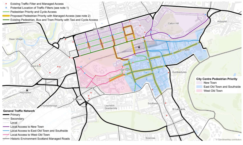
Here are the headlines:
- Edinburgh is very congested and that’s something we have to tackle to hit net zero, as well as accommodate growth: land has been set aside for around 37,000 new houses in and around the city over the next few years.
- How and when these changes are happening are yet to be outlined in detail. But expecting some / most of it within a year.
- Traffic modelling shows an expected 10% traffic evaporation once these new proposals go through – the Council has a 30% reduction target in car kilometres by 2030.
- The proposals to restrict traffic on the bridges etc partly depend on letting traffic flow (partially) through Holyrood Park – Historic Environment Scotland (HES) owns Holyrood Park and is currently consulting on the park’s future – the Council and HES will have to work together.
- Scott Arthur said he does not foresee any changes to Lothian Bus routes through the city centre, but of course Lothian Buses makes up its own routes, not the Council.
- This is not a car ‘ban’. Residents and businesses will retain access to areas like Cowgate [editor: unanswered questions if any of proposed areas will actually be pedestrianised].
- The new proposals mean re-examining plans to make Lothian Road a ‘boulevard’.There is an opportunity to widen pavements on the bridges as well as restrict through-traffic.
- The Council is considering restricting vehicle access to Calton Road from Leith Street i.e. where the back of Waverley Station is.
- Any changes to Picardy Place will be incremental e.g. possibly again allowing vehicles to turn onto London Road.
- The fundamental challenge is the volume of traffic in the city. However, the plans aim to make it easier for people who really need to drive. The tram network is planned to double and bus journey times are planned to decrease by 25% within a decade.
- The Council and Network Rail are talking about opening certain sections of the South Suburban Railway i.e. Slateford to Portobello, but not the entire loop. Timescale? 2035. Ultimate permission will come from Network Rail.Please email us if you’d like to be sent the slide deck / Zoom chat.
Further reading: