For our latest street audit, Living Streets activists focussed on the sprawling roundabout where Polwarth Gardens and Polwarth Crescent converge, and on the associated ‘rat run’ along Polwarth Crescent and Yeaman Place.
We identified a wide range of problems faced by pedestrians at a large number of locations (38) along a relatively short length of street corridor. The most frequent problem was narrow pavements which fail to meet the City Council’s own ‘Street Design Guidance’. Overall we found that the general dominance (speed, volume, noise etc) of motor traffic makes this a largely unpleasant place for pedestrians. The biggest concentration of pedestrian-unfriendly features are at and around the roundabout – and we advocate a major reduction in carriageway space here to make this a much more attractive place to live, shop, work, and linger.
We hope that our illustrated report (link) will stimulate discussion among local people and at Merchiston Community Council – and lead on to action by the City of Council to make pedestrian safety and convenience the top priority locally.
The City of Edinburgh Council is in the early stages of presenting a plan called Corstorphine Connections to improve walking, wheeling and cycling in the south Corstorphine area. So far, there are no plans to comment on but we would like to submit some key areas for improvement with respect to walking and wheeling around the area.
LSE has walkability criteria that we have accessed against south Corstorphine and would like the following to be addressed for the scheme delivery.
The pedestrian conditions in this area are currently very poor on some important streets and the entire area is dominated by traffic, making pedestrian movement difficult and unpleasant.
Walkability criteria
Convenient pedestrian crossing points
St John’s Road
Pedestrian crossing points are generally poor. We have timed some key crossing points:
Crossing over SJR near Station road Green man – 6 seconds Waiting time – 1 min 20 seconds
Crossing over Clermiston Road at SJR Green man – 5 seconds Waiting time – 1 min 28 seconds
This means a pedestrian heading along St John’s Road and looking to cross the road will have a waiting time of 2 minutes 40 seconds to get over one junction with 11 seconds to cross 6 lanes of traffic.
Crossing at White lady on SJR
Green man – 5 secs
Waiting time – 1min 30 seconds
This crossing is frequently used by pedestrians yet has a very long wait and mere seconds to get over the road.
Suggested Action: Improve pedestrian crossing times on St John’s Road.
Saughton Road North
This is a fast and busy road. At the moment there are only two pelican crossings along this entire residential stretch of the south Corstorphine area, with a third (slow) pelican crossing point at the junction with Broomhouse Road.
Suggested Action: Additional pelican crossing point on Sycamore Terrace as a minimum. Improve pelican crossing time at Broomhouse Road.
Corstorphine High Street/Ladywell Road
This is a fast and busy road. There is only one pelican crossing along this entire stretch, which has a range of community amenities including doctors’ surgery, nurseries, primary school, church, greenspace and community hall.
Suggested Action: Upgrade pedestrian refuge to pelican crossing on Ladywell Road.
Meadow Place Road
The crossing treatment for getting over the junction at Meadow Place Road/Ladywell Road is abysmal for pedestrians. If you are heading to Tesco on foot on the south side of Ladywell Road you have to wait to get across five pelican crossings. Any pedestrian looking to cross this junction to/from Ladywell Road has no less than three points to cross.
Suggested Action: Assess this junction for improved pedestrian movement and reduce waiting times.
Traffic-light crossing points along this road are not very frequent. This is a busy and fast road with two high schools and should have better provision.
Suggested Action: Provide pelican crossing on south-side of the overpass.
Non-traffic light junctions
Junction treatments throughout the area makes crossing the road difficult for pedestrians. Junctions often have wide bellmouths, lots of traffic, narrow pavements, poor road surface and a lack of dropped kerbs. They also sometimes have poor sightlines.
Suggested Action: Tighten junction radii, provide continuous footway across residential junctions feeding onto High Street, Ladywell Road, Saughton Road North, St John’s Road.
Pavements
Pavements throughout the south Corstorphine area are less than minimum width as described by CEC’s Street Design Guidance.
Some important pedestrian desire lines have incredibly narrow pavements. Problem streets include:
Manse Road Station Road Sycamore Terrace Corstorphine High Street Ladywell Road Ladywell Avenue
Featherhall Avenue Sections of St Johns Road Sections of Saughton Road North Kirk Loan Meadowhouse Road Sections of Meadow Place Road
Generally, most residential streets in the whole south Corstorphine area are narrower than 2 metres as a bare minimum as per Street Design Guidance.
Suggested Action: Widen pavements on key pedestrian thoroughfares and desire lines, especially around schools and retail.
Pavement clutter and barriers are common. Examples include:
Residential bins on St Johns Road
Much pavement clutter on St Johns Road, which we covered in our pedestrian clutter audit of the area and submitted to CEC
Guardrails at north end of Kirk Loan, the south ends of Meadow Place Road and Saughton Road North
Guardrails narrowing access points on toucan crossing on Meadow Place Road
Barriers on Quiet Route 9 at Ladiebridge, Traquair Alley and the Paddockholm.
Steps to access Traquair Alley from Corstorphine Road
Bollards at junction between Station Road and Meadowhouse Road
Suggested Action: Remove clutter, barriers and guardrails, replace wheelie bins with communal bins on St John’s Road
Pavement parking and parking across dropped kerbs is another common problem. Hotspots for this behaviour include:
Pavement parking on Corstorphine High Street (so common you can see it on Google Streetview)
Pavement parking on north section of Kirk Loan, especially next to the retail units (so common you can see it on Google Streetview)
Parking over dropped kerb on Broomhall Avenue (so common you can see it on Google Streetview)
Pavement parking throughout much of Carrick Knowe.
Suggested Action: Provide double yellow lines over dropped kerbs to stop inconsiderate parking, widen pavements, if appropriate and not cluttering pavement provide bollarding to stop pavement parking
Quality of footway surface can be poor, due to lack of maintenance and pavement parking. Some examples of this include:
South side of Meadowhouse Road from Saughton Road North junction.
Tree roots rendering the off-road path at Pinkhill difficult to negotiate for people who require mobility aids
Featherhall Avenue
Most of Carrick Knowe residential streets
Suggested Action: Improve footway surfaces
Other points of note
LSE Edinburgh members live in this area and are aware of the following “rat runs”, that make getting about as a pedestrian more difficult. We think it is important these cut throughs are addressed, as they increase traffic in the area and make residential streets less accessible for walking and wheeling.
From Saughton Road North, cutting through Meadowhouse Road, Pinkhill to Corstorphine Road (and the opposite direction).
From Saughton Road North, cutting through Castle Avenue, Ladywell Avenue (south) to Meadow Place Road (and the opposite direction).
From Saughton Road North, cutting through Dovecot Road, Ladywell Avenue (south) to Meadow Place Road.
From Corstorphine High Street, cutting through Manse Road to St John’s Road.
From Corstorphine High Street, cutting through Featherhall Avenue to St John’s Road (and the opposite direction)
From St John’s Road, cutting through Kirk Loan to Sycamore Terrace.
From Meadow Place Road, cutting through Featherhall Crescent South and Featherhall Avenue onto High Street.
From Saughton Road North, cutting through Corstorphine Park Gardens, Station Road onto St John’s Road (and the opposite direction).
From Saughton Road North, cutting through Meadowhouse Road, Station Road onto St John’s Road (and the opposite direction).
Some of these driver cut throughs are particularly problematic for families looking to walk to school. Featherhall Avenue, Ladywell Avenue, Kirk Loan and Manse Road are problem streets for families walking to Corstorphine Primary School. Meadowhouse Road is problematic for Carrick Knowe Primary School.
Suggested Action: Introduce filtered permeability to keep rat-running drivers to main roads.
Living Streets Edinburgh Group very much welcomes this scheme, which will secure a big improvement in the quality of the public realm – with particular benefits for the safety and convenience of walking, in line with the latter’s place at the top of the Scottish Government’s ‘Sustainable Travel Hierarchy’.
We are surprised that footway widths are not specified, although we understand that in the new design ‘the north footway [of Newbattle Terrace] varies from 2.25 to 3.5m, with a couple of pinch points of around 2m’ and ‘the south footway is 3.0 – 3.1m, with a pinch point of 2.9m.’ This is reasonably in line with the Council’s ‘Street Design Guidance’ (SDG) which stipulates that the footway width should be an ‘absolute minimum’ width of 2m, ‘only allowed in short sections’.
The footprint of the scheme has been extended northwards up Pitsligo Road as far as the junction with Woodcroft Road, in order to accommodate a new contraflow cycle lane. The latter is welcome in itself, but should be matched by a widening of the parallel footways on this section (currently only 1.5-1.55m wide) in order to satisfy the ‘absolute minimum’ of 2m laid down in the SDG. The Convenor of the Council’s Transport & Environment Committee emphasised at the recent launch of the ‘Cut the Pavement Clutter’ project that the SDG ‘must be applied’ to all schemes, and noted the Council’s ‘wall to wall’ approach, ie not just upgrading the road carriageway, but also enhancing the parallel footways.
The creation of a continuous footway along the north side of Newbattle Terrace at the Pitsligo Road junction is very welcome, but pedestrian passage over the continuous footway should be protected by (i) road markings warning southbound (downhill) cyclists to give way to pedestrians, and (ii) tactiles at the edge of the former footway lines (to indicate to people with visual disabilities that vehicles and cycles cross this area – vehicles northbound only, and cyclists in both directions).
We suggest that any vehicle flow displacement on to Clinton Road should be monitored, and, if necessary, further action should be taken to deal with any problems caused by displaced traffic.
It is currently impossible for pedestrians to maintain social distancing on many Edinburgh streets, which have pavements that are not wide enough. As ‘lockdown’ measures are eased, but social distancing requirements maintained with more people on the street, it will be even more vital to increase the amount of safe space for walking. This will be a particular challenge when schools eventually re-open. Wider measures – notably to encourage cycling – will also be needed when lockdown measures are eased to ensure safe, efficient transport, with a likely reduction in the capacity of Edinburgh’s bus network. However, now more than ever, action is needed to ensure that walking’s place at the top of travel hierarchies is put into practice.
This paper focus on five immediate measures to encourage walking. Many of these measures could be introduced at little cost while the additional £10m funding from the Scottish Government could be used to fund others, including the removal of larger, more complex structures such as the obsolete ‘real-time’ parking displays.
There are a number of resources which the Council has commissioned in recent years which contain specific suggestions to improve the walking environment on streets, such as the ‘Street Life Assessments’, ‘Street Reviews’ by Living Streets Scotland and the recent work by LSEG on ‘Tackling Street Clutter’. We recommend that these resources are revisited and used to guide immediate measures.
1) Pavement Widening
We want to see a programme of temporary pavement widening, focusing on high footfall streets such as ‘retail/high street’ and public transport corridors. The classification of streets in the Edinburgh Street Design Guidance provides a ready strategic framework to assist in identifying such streets. This will in places require removal of parking/loading/waiting permissions. To complement this process, the following streets have been identified as potential candidates by the LSEG Committee members and also from social media (see especially:
South Bridge/Nicolson Street/Clerk Street
Great Junction Street
Ferry Road
St Johns Road/A8
Queensferry Road
George IV Bridge
London Road
Easter Road
Dalry Road
Milton Road East
Lower Granton Road
Niddrie Mains Road
Raeburn Place
Morningside Road
Morrison Street
Captains Road
Liberton Road
Burdiehouse Road
Frogston Road
Comiston Road
Colinton Road
2) Road closures
In residential areas, many streets could be closed to through traffic, while retaining access by motor vehicles to/for residents through barriers (‘filters’). This will reduce traffic on local streets, making walking and cycling safer. This may apply particularly in residential areas (eg Oxgangs, Bingham, Lochend, Stenhouse etc).
3) Guardrails
Guardrails which hem in pedestrians over long stretches of pavement (for example, Slateford Road bridge) are particularly inappropriate at present. The Council already has a presumption against these features unless there is a compelling need, but Edinburgh has a legacy of many such guardrails from earlier, outdated street design philosophies. A programme of removal should be introduced immediately to accelerate the removal of inappropriate guardrails.
4) Decluttering
Removal of streets clutter is a ‘quick win’ to aid walking and social distancing. As with guardrails the Council already has a policy of de-cluttering which should be accelerated at the present time. This could include ‘sweeps’ of roads to remove old roadworks debris such as traffic cones, sandbags, old signs etc which litter many streets, and also removal of redundant and empty signage poles (many of which have been notified to locality teams as part of LSEG’s ‘tackling Street clutter’ project).
5) Signals
Traffic signals, including signalled pedestrian crossings, should be reconfigured so as to give pedestrians priority – eg immediate ‘green man’, increased crossing time, single crossing of staggered crossings, etc. This will aid walking movement and also reduce the risk of pedestrian congestion at lights, islands, etc.
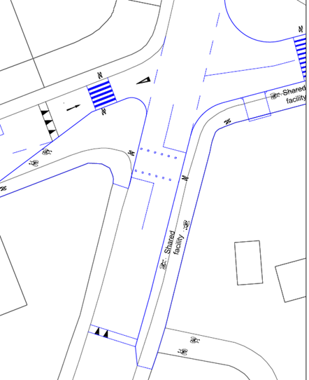
Living Streets Edinburgh would like to lodge a formal objection to RSO/20/01 – Redetermination – Braidburn Area
We fundamentally object to the creation of “Shared Facility” between cyclists and pedestrians, where cyclists share the same narrow space as vulnerable pedestrians. We note that both of the narrow “Shared Facilities” sections are on downhill sections, meaning cyclists will be traveling at speeds, which would an unacceptable risk to pedestrians.
We note that the pavement on the north side of Braidburn terrace doesn’t meet the Street Design Guidance “Absolute minimum footway width” but nothing is being done to resolve the issue.
We note that this project fails to adhere to the Scottish Planning Policy movement hierarchy.
Segregated cycling space should be created, but not to the detriment of pavement users.