Introduction
Living Streets Edinburgh Group (LSEG) is the local voluntary arm of the national charity, Living Streets, which campaigns for better conditions for ‘everyday walking’. In LSEG our key aim is to promote walking as a safe, enjoyable and easy way of getting around the city.
A fundamental point is that all proposals and designs must explicitly conform to the Edinburgh Street Design Guidance (ESDG) for the category/categories of street affected. Until the adoption of finalised Detailed Design Sheets for the ESDG, the latter’s Design Principles (as already adopted by the Council) should be adhered to, for example with regard to:
Space:
- An increase (or no net loss) of pedestrian space.
- Footways meet recommended widths.
- Conflicts with cyclists are avoided, with dedicated and well-defined space provided for pedestrians (including separated ‘tiger’ crossings).
Crossings:
- Junctions make foot crossing easier by being raised, with radii of corners and widths minimised
- In busier areas, controlled crossings are provided in convenient places, with acceptable waiting and crossing times.
- Pedestrian priority is made clear at all the key crossing points of the cycle routes, eg with continuous footways across side streets at junctions.
Equalities:
- The design meets the requirements of the 2010 Equality Act by considering features to make the streets accessible to people with disabilities such as dropped kerbs (where continuous footways are not feasible), seating and tactile paving.
Public realm:
- The footway is made free from clutter.
- Guardrails are avoided / removed.
Impact of traffic:
- If the area is a residential or shopping street or busy pedestrian route the speed is 20mph and the design helps to achieve this speed
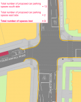
- The level of parking and access to motor vehicles is appropriate and does not dominate the space.
Holyrood Park Road to Ratcliffe Terrace: general observations.
The route as a whole does not follow any natural pedestrian desire line and as such is clearly intended to generally benefit cyclists rather than people walking. This highlights the need to complement schemes like this with a programme of improvements specifically aimed at major routes which pedestrians want to use in the city. Nonetheless, we welcome a number of incidental improvements along the route, especially the use of continuous pavements, and assume that all streets will be subject to rigorous application of the Street Design Guidance as set out above.
Our main point is that we think that the scheme as a whole misses an opportunity to re-allocate ‘road space’ to ‘people space’, or in other words to prioritise ‘place over movement’. While we welcome the reduction of a lane on parts of Holyrood Park Road and Dalkeith Road, the area around the Park and the Commonwealth Pool will continue to feel – and be – dominated by traffic, which is unfortunate in such a unique location. There appear to be no improvements at all to crossing Dalkeith Road – perhaps the biggest obstacle to walking on the whole route. As such, we feel the whole scheme design misses the opportunity to be ‘transformative’.

The easterly starting point (at the boundary of Queen’s Park) highlights the inadequacy of walking (and cycling) provision in the Park immediately to the east, where there are two small but busy and hostile roundabouts to negotiate. LSEG has campaigned for improved paths and road crossings for people walking throughout the Park. The Council should take this opportunity to encourage Historic Environment Scotland to adopt measures to make walking and cycling safer and more attractive in the Park itself, joining up with this scheme.
Towards the westward sections of the route, the Aecom drawings show much fewer design changes than at the eastern end. For example, there are minimal changes shown to South Gray Street, where we would expect to see at the minimum, continuous footways across side roads like Middleby Road and several access points to residential and business properties. Is this because Aecom propose few changes at these western parts, or because they have yet to complete design work?
The route ends at Ratcliffe Terrace which is a major pedestrian route and one in serious need of full decluttering. We would ask that this should be incorporated into the scheme design. Between the two junctions of the scheme with Ratcliffe Terrace (West Mayfield and Duncan Street), the busy pavements are also very narrow in places – only 1.6m wide on the west side just north of Fountainhall Road. Widening pavements in this section of Ratcliffe Terrace should be included as part of the scheme.
There are several locations (junctions of Dalkeith Road/Salisbury Place and Dalkeith Road/Blacket Place and much of Duncan Street) where the pavement has a clear space of less than 1 metre; this means that the streets cannot be used by someone using a wheelchair. Unless these deficiencies are addressed, we believe that the scheme would breach the Equality Act.
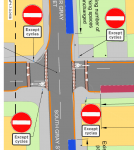
We are unhappy to see repeated proposals for cyclists to use pavements at crossing points, eg at the junctions of Holyrood Park Road/East Parkside, Dalkeith Road/Holyrood Park Road, Dalkeith Road/Blacket Place and Minto St/Blacket Avenue/Duncan Street. This designs conflict between pedestrians and cyclists into the scheme.
No cycle parking is shown; if it is intended to provide cycle parking (for which we expect to see a demand), the locations need to be carefully considered and pedestrian desire lines avoided; this has been a serious weakness in many recent cycle parking installations. Cycle parking should ideally be on the carriageway, or in open spaces such as in front of the Commonwealth Pool.
We are not necessarily convinced that two-way cycle path (south side of Holyrood Park Road, east side of Dalkeith Road) is the best solution; a one-way cycle path (on each side of the road) should be considered. This may be easier for both pedestrians (who do not have to look both ways) and for cyclists. This raises wider questions about the strategy for improving cycling infrastructure which we appreciate needs wider discussion.
Holyrood Park Road to Ratcliffe Terrace: location-specific observations
These observations relate to specific changes which we would like to see to the initial design; in general, we are therefore happy with the proposals except where stated above or below.
Holyrood Park Road:
- The (‘Copenhagen-style’?) kinks in the cycleway on the south side divert the pavement away from the pedestrian desire line and should be avoided unless there are compelling reasons otherwise.

Junction of Holyrood Park Road with Dalkeith Road
- We are disappointed to see no apparent improvement for pedestrians at this extremely important and pedestrian-hostile signalled junction, both north-south (across Holyrood Park Road) and east-west (across Dalkeith Road). The scope for such improvements appears not to have been considered at all.
- We think that the cobbled drainage ‘ditch’ on the north side of Holyrood Park Road at this junction should be replaced, as it is a significant barrier for disabled people.


Dalkeith Road
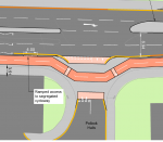
 We have previously stated our opposition to the introduction of any more ‘floating bus stops’ until an effective monitoring and evaluation process has been carried out on their impact on Leith Walk. In the absence of any progress on this to date, we are therefore unhappy with this proposed feature. Some southbound cyclists at this location are likely to be travelling downhill at high speeds and this also needs to be taken into account in design of the cycle path.
- The west side of Dalkeith Road appears to have been completely ignored in the design. The pavement is badly cluttered and should have continuous pavements installed eg at the entrance to the Salisbury Arms.Junction of Dalkeith Road with Salisbury Place
- Major improvement is required at this junction, which is a fairly busy street but the southern pavement is only 80cm wide at the guardrails at the eastern end. The pavement itself is only 1.25m wide.
Blacket Place
-
 the maximum width of the pavement at the entry to Blacket Place is only 90cm which of course is unacceptable, not only failing to meet Street Design standards, but also excluding wheelchair users. We think that this can only be addressed by adopting option 2 (stopping up the street at this point).
 - on the south side of Blacket Place, immediately to the west of the Dalkeith Road junction, there are two access points with no dropped kerbs – the footway should be widened, extended and made continuous.
- There is no tactile paving at the crossing of Dryden Place.
- The opportunity should be taken during the works, or their planning, to inform frontagers of their responsibility to cut back vegetation that overhangs or narrows the footway, which is a significant problem in places. It is important to include this kind of intervention to make streets for people-friendly, as well as infrastructure.

Blacket Avenue
- The drawings incorrectly show a pavement on the north side of this street. Vegetation encroachment is an issue on the southern side.
Duncan Street
- T
 he pavements along the length of this street are inadequate, being only 1.3m and 1.2 m wide on the north and south sides respectively to the west of Minto Street. Because of various poles and lamp posts, neither side of the street is currently wide enough for a wheelchair user to use it and this must be remedied.
 - There are no dropped kerbs at the South Gray Street junction.The pavements on the westernmost part of the street near the Ratcliffe Terrace junction are also much too narrow.
- A continuous pavement needs to be installed at the Hendry and Macdonald garage access.

South Gray Street
 Numerous continuous pavements should be installed at access points and junctions on this street; we do not understand why Aecom have not included these in the proposals.
West Mayfield
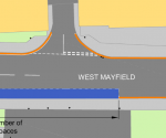 A continuous pavement is required at the massive bell mouth access between number 12 and 14 on the north side of the street near the Ratcliffe Terrace junction.
- We assume that there are no plans to improve the signalled junction at Ratcliffe Terrace for pedestrians? This would be a missed opportunity as the signal phasing is not currently walk-friendly.